
Category:Boreal forest of Canada
Canadian region characterized by coniferous forests | |||||
| Upload media | |||||
| Instance of | |||||
|---|---|---|---|---|---|
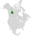
| Location |
| ||||
| |||||
Subcategories
This category has the following 5 subcategories, out of 5 total.
C
E
N
S
Media in category "Boreal forest of Canada"
The following 98 files are in this category, out of 98 total.
-
 Central Canadian Shield forests map.svg 1,712 × 1,992; 338 KB
-
 Eastern Canadian Shield taiga map.svg 1,712 × 1,992; 344 KB
-
 Interior Alaska-Yukon lowland taiga map.svg 1,712 × 1,992; 347 KB
-
 Mid-Continental Canadian forests map.svg 1,712 × 1,992; 346 KB
-
 Muskwa-Slave Lake forests map.svg 1,712 × 1,992; 339 KB
-
 Taiga Landscape in Canada.jpg 3,008 × 1,960; 2.84 MB
-
_DDumais.jpg/120px-2005-09-16_BOP_65_(01)_DDumais.jpg) 2005-09-16 BOP 65 (01) DDumais.jpg 1,280 × 960; 579 KB
2005-09-16 BOP 65 (01) DDumais.jpg 1,280 × 960; 579 KB
-
 2018 boreal tree species trends.jpg 667 × 515; 155 KB
-
 Arctic taiga south of Inuvik, NT.jpg 5,436 × 3,636; 20.34 MB
-
 Aufeis cone at Joe Creek-Firth River confluence, Ivvavik National Park, YT.jpg 6,048 × 4,032; 20.67 MB
-
 Aufeis on Wolf Creek above Firth River confluence, Ivvavik National Park, YT.jpg 6,048 × 2,388; 10.65 MB
-
 Bedrock slope with taiga, Yellowknife, NT.jpg 5,586 × 3,786; 16.13 MB
-
 Bend in Firth River above Joe Creek confluence.jpg 6,048 × 3,468; 15.1 MB
-
 Bend in Firth River canyon reach, Ivvavik National Park, YT.jpg 4,032 × 5,248; 24.36 MB
-
 Blak spruce Muskeg.JPG 600 × 800; 295 KB
-
 Boreal Flora.jpg 2,736 × 3,648; 5.44 MB
-
 Boreal forest near Thompson, Manitoba from the train.JPG 3,648 × 2,056; 857 KB
-
 Boreal forest of Canada 03269.jpg 1,536 × 2,048; 1.41 MB
-
 Boreal Forest Ring.jpg 1,760 × 1,200; 329 KB
-
 Boreal forest.JPG 1,536 × 2,048; 2.78 MB
-
 Boreal Forest.jpg 4,160 × 2,340; 3.04 MB
-
 Borealforest.jpg 350 × 263; 33 KB
-
 Campsite along Firth River at Joe Creek confluence, seen from above.jpg 5,748 × 3,792; 19.37 MB
-
 Canadian Taiga.jpg 716 × 509; 92 KB
-
 Carmacks Banner.jpg 16,810 × 2,407; 22.33 MB
-
 Carns Road, Inuvik, NT.jpg 5,772 × 3,672; 17.99 MB
-
 Cañón Miles, Yukón, Canadá, 2017-08-26, DD 130-132 PAN.jpg 8,429 × 3,793; 14.09 MB
-
 Cañón Miles, Yukón, Canadá, 2017-08-26, DD 144-154 PAN.jpg 14,304 × 4,247; 16.65 MB
-
 Cladonia-stellaris taiga.jpg 3,888 × 2,592; 11.74 MB
-
 Climate change is real folks.jpg 2,592 × 1,944; 1,023 KB
-
 Crooked Creek landscape, Ivvavik National Park, YT 2.jpg 5,844 × 3,756; 21.98 MB
-
 Crooked Creek landscape, Ivvavik National Park, YT.jpg 5,460 × 3,240; 18.3 MB
-
 Dusk view of Niven Lake and Back Bay, Yellowknife, NT, from Explorer Hotel.jpg 5,778 × 3,252; 11.77 MB
-
 Fireweed Yukon.jpg 1,800 × 1,200; 473 KB
-
 Firth River above Wolf Creek confluence, Ivvavik National Park, YT.jpg 5,844 × 3,660; 17.29 MB
-
 Firth River banks in mountain reach, Ivvavik National Park, YT.jpg 5,832 × 3,600; 18.19 MB
-
 Firth River bending in mountain reach, Ivvavik National Park, YT.jpg 6,048 × 4,032; 25.09 MB
-
 Firth River landscape at Sheep Slot Rapids, Ivvavik National Park, YT.jpg 6,048 × 3,852; 22.38 MB
-
 Firth River looking upstream from the Muskeg Creek confluence.jpg 5,796 × 3,408; 15.97 MB
-
 Firth River, tributary and V-shaped valley, Ivvavik National Park, YT.jpg 6,048 × 3,564; 18.43 MB
-
 Firth River-Joe Creek confluence westerly view.jpg 6,048 × 4,032; 17.76 MB
-
 Forêt - Parc national des Hautes-Gorges-de-la-Rivière-Malbaie.jpg 3,264 × 2,448; 1.25 MB
-
 Gaspé taiga.jpg 3,072 × 2,304; 1.75 MB
-
 Grands-Jardins NP 09.jpg 4,288 × 2,848; 12.09 MB
-
 Grey sky & trees -- Yukon.jpg 3,000 × 4,000; 7.26 MB
-
 Inuvik panorama from cemetery.jpg 6,048 × 3,036; 13.71 MB
-
 Inuvik Regional Hospital from south of town.jpg 5,292 × 2,076; 7.91 MB
-
 Inuvik skyline.jpg 6,048 × 2,502; 10.68 MB
-
 Ivvavik National Park banner Crooked Creek.jpg 5,844 × 835; 6.1 MB
-
 Kenn Borek Air Twin Otter taking off from airstrip in Ivavvik National Park.jpg 5,190 × 3,870; 12.36 MB
-
 Lac-hebecourt.jpg 6,000 × 4,000; 7.29 MB
-
 Lago Esmeralda, Yukón, Canadá, 2017-08-26, DD 129.jpg 8,688 × 5,792; 9.68 MB
-
 Landscape with tors, clouds and spruce trees in Ivvavik National Park, YT.jpg 6,048 × 4,032; 18.02 MB
-
 Midnight sun from Arctic Chalet, Inuvik, NT 3.jpg 6,048 × 4,032; 12.57 MB
-
 Mountain and brook draining into Firth River, Ivvavik National Park, YT.jpg 6,048 × 4,032; 16.37 MB
-
 Mountain and tundra landscape in Ivvavik National Park, YT.jpg 5,316 × 3,276; 16.38 MB
-
 Mountain view in Robson valley.jpg 4,928 × 3,264; 9.7 MB
-
 Nahanni-ranges-tuchitua.jpg 760 × 570; 233 KB
-
 North end of the Dempster Highway and Inuvik buildings.jpg 6,048 × 2,616; 11.07 MB
-
 Northern Canadian Shield taiga map.svg 1,712 × 1,992; 341 KB
-
 Northernmost extent of forest in Firth River's canyon reach, Ivvavik National Park, YT.jpg 5,880 × 3,312; 20.44 MB
-
 Northwest Crown Fire Experiment.png 2,095 × 1,402; 4.43 MB
-
 Peyto Lake in winter.jpg 8,001 × 2,892; 16.62 MB
-
 Poplar muskeg.JPG 824 × 594; 476 KB
-
 René-Levasseur island.JPG 2,048 × 1,536; 1.05 MB
-
 Río Yukón, Carmacks, Yukón, Canadá, 2017-08-27, DD 01-04 PAN.jpg 16,810 × 4,022; 21.6 MB
-
.jpg/120px-Saint-Thomas-de-Cherbourg_(Grande-Branche_et_Cinquante).jpg) Saint-Thomas-de-Cherbourg (Grande-Branche et Cinquante).jpg 5,969 × 2,093; 12.44 MB
Saint-Thomas-de-Cherbourg (Grande-Branche et Cinquante).jpg 5,969 × 2,093; 12.44 MB
-
 Saline Lake at La Saline Natural Area, Alberta.jpg 4,000 × 3,000; 555 KB
-
 Sheep Slot Rapids and mountain landscape, Ivvavik National Park, YT.jpg 4,032 × 5,648; 20.23 MB
-
 Sheep Slot Rapids, Firth River, Ivvavik National Park, YT.jpg 6,048 × 3,648; 16.83 MB
-
 Small aufeis by Firth River near Joe Creek, Ivvavik National Park, YT.jpg 5,496 × 4,032; 20.86 MB
-
 Small lake in the depths of the taïga.jpg 2,288 × 1,712; 943 KB
-
 Spruce trees, tors and caribou antlers at Wolf Creek campsite, Ivvavik National Park, YT.jpg 5,592 × 3,756; 20.12 MB
-
 Stegosaurus Ridge, Ivvavik National Park, YT.jpg 6,048 × 4,032; 23.46 MB
-
 Sunset on Castle Creek.jpg 872 × 1,166; 574 KB
-
 Taiga and bedrock in Yellowknife.jpg 6,048 × 4,032; 20.76 MB
-
 Taiga and bedrock outcrops behind Explorer Hotel, Yellowknife, NT.jpg 5,844 × 4,032; 21.15 MB
-
 Taiga and stream south of Inuvik, NT.jpg 3,848 × 5,032; 15.6 MB
-
 Taiga in Yellowknife, NT.jpg 3,600 × 5,576; 16.75 MB
-
 Taiga off Carn Street, Inuvik, NT.jpg 5,772 × 3,648; 23.28 MB
-
 Thuja occidentalis lac Dupaquet.jpg 2,448 × 3,264; 4.3 MB
-
 Tors behind Wolf Creek campsite on Firth River, Ivvavik National Park, YT.jpg 6,048 × 3,240; 12.52 MB
-
 Trail into taiga, Inuvik, NT.jpg 3,920 × 5,952; 23.68 MB
-
 Trail through taiga near Arctic Chalet, Inuvik, NT.jpg 4,032 × 6,048; 21.68 MB
-
 Tundra landscape with clouds, trees mountains and lens flare 2.jpg 6,048 × 4,032; 12.61 MB
-
 Tundra landscape with mountains and small pond, Ivvavik National Park, YT.jpg 5,940 × 3,864; 21.33 MB
-
 Tundra landscape with pond reflecting spruce trees, Ivvavik National Park, YT.jpg 5,832 × 3,660; 19.79 MB
-
 Tundra landscape with trees, clouds, mountains and lens flare, Ivvavik National Park, YT.jpg 5,856 × 3,828; 4.36 MB
-
 Understory vegetation.jpg 2,400 × 2,400; 6.85 MB
-
 View across Firth valley in Ivvavik National Park with hikers.jpg 5,208 × 3,936; 20.85 MB
-
 View east along Carn Street, Inuvik, NT.jpg 5,652 × 3,114; 15.27 MB
-
 View north from Explorer Hotel, Yellowknife, NT.jpg 6,048 × 3,318; 13.96 MB
-
 View up Joe Creek above Firth River, Ivvavik National Park, YT.jpg 6,048 × 4,032; 16.22 MB
-
 Warnschild Goose Bay.JPG 1,166 × 778; 322 KB
-
 Watson River Upper Canyon.jpg 9,909 × 4,521; 44.4 MB
-
 Wolf Creek valley, Ivvavik National Park, YT.jpg 6,048 × 3,588; 18.2 MB
-
 Yukon banner 2.jpg 8,429 × 1,204; 5.39 MB
-
 Yukon banner 3.jpg 16,805 × 2,406; 18.6 MB


_DDumais.jpg)


.jpg)